- Government
-
- City Council & Mayor Ordinances Resolutions Agendas and Meetings Boards and Commissions City Charter Contact Us
- Departments A-Z Administration City Attorney City Manager City Recorder Court Human Resources Community Development Building Economic Development Planning Tourism Emergency Management
- Finance Library Municipal Services Billing (Water Bill) Police 9-1-1 Code Compliance Public Works Engineering Maintenance Operations
-
- Community
- Business
- How Do I
-
- Find info on Public meetings Apply for a job Apply for an internship Contact the City Council Submit a Public Records Request Report an issue in Newberg Find a leak Find pavement maintenance information View the City Events calendar Apply for a library card Find the city on Social Media
- Pay my Municipal Services Statement (Water Bill) Read my Municipal Services Statement (Water Bill) Access Municipal Services Programs Know if I need a building permit Apply for a building permit Schedule an inspection Recycle Buy Compost Get a water conservation kit
- Apply for a Police ride-along Volunteer as a Reserve Officer Pay My Parking Ticket File a Code Complaint Obtain an animal permit
-
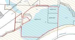
ANX21-0002 Annexation of 5 parcels in the Riverfront Master Plan area
FILE NO: ANX21-0002
REQUEST: Annexation of 5 parcels in the Riverfront Master Plan area
LOCATION: 1609 NE Waterfront Street, 712 NE Fourteenth Street, 1610 NE Waterfront Street, and two parcels south of E Fourteenth Street which have no address. The Tax Map and Parcel numbers are:
TAX LOTS: R3230-00401, R3230-00100, R3230-00200, R3229-02700, R3229-02800
APPLICANT: Goedel, Baker, Stonebrink, and City of Newberg
ZONE: County VLDR-5 Very Low Density Residential (R3230-00401), HI Heavy Industrial and MR-2 Mineral Resource (R3230-00100), VLDR-5 Very Low Density Residential (R3230-00200), and PWS Public Works/Safety District (R3229-02700 and R3229-02800)
CURRENT USE: Single Family Residences (2), Shopes, and vacant
SITE SIZE: 29.38 acres including adjoining public right-of-way
PROPOSAL: Consider an application to annex a 5 parcels plus right-of-way for NE Waterfront Street and E Fourteenth Street into the Newberg city limits and change the zoning from Yamhill County VLDR-5 Very Low Density Residential (R3230-00401), HI Heavy Industrial and MR-2 Mineral Resource (R3230-00100), VLDR-5 Very Low Density Residential (R3230-00200), and PWS Public Works/Safety District (R3229-02700 and R3229-02800) to Newberg R-2 (R3230-00401), C-4/RD and CF/RD (R3230-00100), C-4/RD (R3230-00200) and CF/RD (R3229-02700 and R3229-02800. The subject properties and adjoining right of way are located within the City’s Urban Growth Boundary and are designated by the Comprehensive Plan Map as: MDR/RD (R3230-00401), COM/RD and P/RD (R3230-00100), COM/RD (R3230-00200), and P/RD (R3229-02700, R3229-02800).


