- Government
-
- City Council & Mayor Ordinances Resolutions Agendas and Meetings Boards and Commissions City Charter Contact Us
- Departments A-Z Administration City Attorney City Manager City Recorder Court Human Resources Community Development Building Economic Development Planning Tourism Emergency Management
- Finance Library Municipal Services Billing (Water Bill) Police 9-1-1 Code Compliance Public Works Engineering Maintenance Operations
-
- Community
- Business
- How Do I
-
- Find info on Public meetings Apply for a job Apply for an internship Contact the City Council Submit a Public Records Request Report an issue in Newberg Find a leak Find pavement maintenance information View the City Events calendar Apply for a library card Find the city on Social Media
- Pay my Municipal Services Statement (Water Bill) Read my Municipal Services Statement (Water Bill) Access Municipal Services Programs Know if I need a building permit Apply for a building permit Schedule an inspection Recycle Buy Compost Get a water conservation kit
- Apply for a Police ride-along Volunteer as a Reserve Officer Pay My Parking Ticket File a Code Complaint Obtain an animal permit
-
Mapping Our History
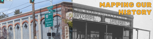
Led by Dr. Caitlin Corning (History), Rachel Thomas (Archives/Library), Jenny Bruxvoort (Library), and Rob Felton (Executive Communication) of George Fox University, Mapping Our History is a digital humanities project involving digitally mapping the downtown with overlays that will identify historic land use, structures, events, and artifacts to tell the story of the city.
This project features the Newberg Collection held in the George Fox University archives and museum which includes photographs, business records, artifacts, historic newspapers, and university publications. Students answered the question “How has the land use of downtown Newberg changed over time and what does this reveal about the community identity?” Selected students located information in the archival collections, conducted research on specific locations, and created mapping overlays that include images and research.
The information is now displayed in maps available to the entire community.